
1. The horizontal and vertical lines, covering the complete area on a map are called ___________.
(a) Longitudes (c) Magnetic Lines
(b) Grid Lines ( ✔ ) (d) Latitudes
2. Which organization prepares the topographical maps in India for the entire country. (a) Indian Cartographic Organisation (c) Directorate of Map Survey
(b) Department of Cartography (d) The survey of India ( ✔ )
3. ‘Degree’ is the proportion which the distances between the two points on the map relates to the distance between the two points on the ground.
(a) True (b) False ( ✔ )
4. A map represents selected natural and ma-made features of the whole or part of the __________ on a sheet of paper.
(a) Earth’s Surface ( ✔ ) (c) Landmass
(b) Country (d) None of the Above
5. Symbols used to represent certain artificial or natural features/objects on the map are called _______________.
(a) Datum Points (c) Reference Points
(b) Conventional Signs ( ✔ ) (d) Reference Signs
6. How is an International demarcated Boundary represented on the map?
Option 1
Option 2
Option 3
Option 4
(a) Option 1 (c) Option 2 ( ✔ )
(b) Option 3 (d) Option 4
7. The science of making maps is called _____________.
(a) Scalography (c) Mapography
(b) Cartography ( ✔ ) (d) Survey
8. Grid Reference should be given in the ___________ format.
(a) Four Figure (c) Ten Figure
(b) Six Figure (d) Any of these ( ✔ )
9. On a map, black/red coloured vertical lines whose numbers increase from West to East, are called _____________.
(a) Northings (c) Eastings ( ✔ )
(b) Grid Lines (d) Bearings
67
10. There are two methods of expressing a scale of the map. One of them is ‘In Words’, What is the other method?
(a) Representative Fraction ( ✔ ) (c) In Degrees
(b) Reference Scale (d) In Distances
11. Ground which is not visible to the observer because of undulations or hills is called _____________.
(a) Unseen Ground (c) Dead Ground ( ✔ )
(b) Undulation Ground (d) No Man’s Land
12. A piece of high ground jutting out of range of hills into lower ground is called ____________. (a) Spur (c) Watershed
(b) Crest ( ✔ ) (d) Ridge
13. Contour lines never touch or cross each other.
(a) TRUE (b) FALSE ( ✔ )
14. In a Grid Reference, the first half represents the _________ value.
(a) Easting ( ✔ ) (c) Latitudinal
(b) Northing (d) Longitudinal
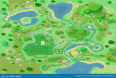
15. In the map given below, what is the four figure GR of the Railway Station?
(a) 0268 (b) 0367 (c) 0267 ( ✔ ) (d) 0368
70
69
68
67
66
65
64
63
97 98 99 00 01 02 03 04
16. If the scale of a map is 1:25,000, then 4 cm on the map will be equal to ___________ on the ground.
(a) 1,00,000 centimeters (c) One Kilometer
(b) 1000 meters (d) All of these ( ✔ )
17. ___________ is the angle formed by a line joining two points and the North-South line. (a) Bearing ( ✔ ) (c) Direction Line
(b) Degree Line (d) Direction Angle
18. A small isolated hill is known as __________.
(a) Single Hill (c) Re-entrant
(b) Knoll ( ✔ ) (d) Salient
68
19. If the map distance between two consecutive km stones on a road is 2 cm, what is the scale of the map?
(a) 1 : 25,000 (c) 1 : 50, 000 ( ✔ )
(b) 1 : 10, 000 (d) 1 inch to 1 mile
20. In the map given at Q No 15 above, what is the four figure GR of Mosque? (a) 0069 (c) 6899
(b) 9968 ( ✔ ) (d) 9969
21. A service protractor measures __________ inches long and 2 inches wide. (a) Four (c) Eight
(b) Five (d) Six ( ✔ )
22. On a map, black/red coloured horizontal lines whose numbers increase from South to North, are called ____________.
(a) Grid Lines (c) Bearings
(b) Northings ( ✔ ) (d) Eastings
23. In the map at Q No 15 above, what is the four figure GR of the Bridge?
(a) 0065 ( ✔ ) (c) 0165
(b) 0066 (d) 0166
24. The slope of a hill expressed as a fraction is known as ___________.
(a) Defile (c) Gradient ( ✔ )
(b) Variation (d) None of these
25. Global Positioning System (GPS) is funded and controlled by the Department of _________ of the United States.
(a) Space (c) Satellite Technology
(b) NASA (d) Defence ( ✔ )
26. A map is said to be Set, when the magnetic NORTH line on the map is pointing in the direction of magnetic NORTH as indicated by the Compass Needle.
(a) True ( ✔ ) (b) False
27. A line drawn on the map joining up all points of equal height above sea level is called ________.
(a) Elevation Line (c) Bearing Line
(b) Height Line (d) Contour Line ( ✔ )
28. In the following diagram of a Prismatic Compass, identify the part marked with number 6.
(a) Milled Wane
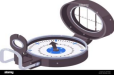
(b) Clamping Screw ( ✔ )
(c) Thumb Ring
(d) Prism
29. The direction having a bearing of 135 degrees is ____________.
(a) North West (c) South South East
(b) West North West (d) South East ( ✔ )
69
30. In the map given at Q No 15 above, what is the six figure GR of the Police Station? (a) 005664 (c) 984643 ( ✔ )
(b) 993636 (d) 987651
31. If you walk along a __________ line, you neither gain nor loose elevation. (a) Magnetic Line (c) Ridge Line
(b) Grid Line (d) Contour Line ( ✔ )
32. Bearings are always measured anti-clockwise. True or False.
(a) TRUE (b) FALSE ( ✔ )
33. While finding own position by Resection/Compass method, if the three rays do not intersect at the same point, a ___________ is formed, the centre of which is to be taken as your own position.
(a) Rectangles of Error (c) Octagon of Error
(b) Triangle of Error ( ✔ ) (d) Rectangle of Error
34. A Pointer Staff is used for _____________.
(a) Showing as object to another person. ( ✔ )
(b) Showing the Bearing to another person.
(c) Identifying an object by another person located at a far away place.
(d) Find the angular difference between two objects.
35. A thick Blue Dot with a black boundary line shown on the map represents ___________. (a) A Dry Well (c) A Trig Height
(b) An Unwalled Well (d) A Walled Well ( ✔ )
36. In the map given at Q No 15 above, what is the six figure Grid Reference of Point 2742 (.2742)? (a) 033653 (c) 653029
(b) 029653 ( ✔ ) (d) 025653
37. Grid Bearing is measured on the map from the Grid North with the help of a ___________. (a) Service Protractor ( ✔ ) (c) Scale
(b) Service Compass (d) Triangle
38. The rise between successive contour lines is known as the ___________. (a) Contour Difference (c) Height Variation
(b) Vertical Interval ( ✔ ) (d) Ridge Variation
39. What is the back bearing of 139 degrees?
(a) 319 degrees ( ✔ ) (c) 419 degrees
(b) 289 degrees (d) 359 degrees
40. A line along a hill or range of hills or mountains from which water flows in opposite directions is called _____________.
(a) Defile (c) Ridge ( ✔ )
(b) Plateau (d) Spur
41. In the following map, identify the conventional sign used/natural feature which has been numbered 5.
(a) Saddle
(b) Survey Tree ( ✔ )
70
(c) Black Tree
(d) Single Tree
42. The deviation of the magnetic needle in the compass from the magnetic NORTH is called ____________.
(a) Magnetic Deviation (c) Magnetic Variance
(b) North Error (d) Compass Error ( ✔ )
43. The difference between True North and Magnetic North is called ___________. (a) Magnetic Variation ( ✔ ) (c) North Variation
(b) Grid Convergence (d) Grid Variation
44. While finding own position by Resection/Compass method, the prominent features selected should not be less than _________ degrees aprt.
(a) 120 (c) 60
(b) 30 ( ✔ ) (d) 45
45. ____________ is basically a “Car Mode” App from Google for your phone: an interface that’s optimized for driving.
(a) Android Auto ( ✔ ) (c) Google Driver
(b) Android Kunjappan (d) Chrome Remote Car
46. The height of an object relative to its surroundings is depicted by ______________. (a) Trig Height (c) Refractive Height
(b) Bench Mark (d) Relative Height ( ✔ )
47. Magnetic Bearing is measured from Magnetic North by using a ______________. (a) Compass ( ✔ ) (c) Pointer
(b) Protractor (d) Triangle
48. _____________ is a program launched by Google Maps to enable its users to contribute to Google Maps.
(a) Google Local Circles (c) Google Mapping Groups
(b) Google Local Guides ( ✔ ) (d) Google Map Suite
49. In the Northern Hemisphere, the ____________ indicates the Position of True NORTH to within 2 degrees.
(a) Great Bear (c) Saptarishi Mandal
(b) Pole Star (d) Dhruv Tara ( ✔ )
50. The difference between True North and Grid North is called _____________. (a) Magnetic Variation (c) North Variation
(b) Grid Convergence ( ✔ ) (d) Grid Variation
51. In the diagram of a Prismatic Compass given at Q No 28, identify the part marked with number 1.
(a) Eye (c) Tongue ( ✔ )
(b) Window (d) Nose
52. In the diagram of a Prismatic Compass given at Q No 28, identify the part marked with number 8.
(a) Round Glass (c) Wind Wane
(b) Milled Wane ( ✔ ) (d) Notched Glass
71
53. The direction which corresponds to a bearing of 22���� degrees is _____________. (a) East North East (c) North North West
(b) North North East (d) West North West ( ✔ )
54. While travelling in the North West direction, if you turn 90 degrees to your Right, which direction will you be travelling?
(a) North (c) East
(b) South West (d) North East ( ✔ )
55. In the diagram of a Prismatic Compass given at Q No 28, identify the part marked with number 7.
(a) Bearing Line (c) Milled Wane
(b) White Line (d) Direction Mark ( ✔ )
56. In the map given at Question number 41 above, the natural feature marked ‘3’ is ___________.
(a) Spur ( ✔ ) (c) Saddle
(b) Re-entrant (d) Northing
57. In the map given at Question number 41 above, the natural feature marked ‘8’ is ____________.
(a) Trig Height (c) Saddle ( ✔ )
(b) Bench mark (d) Survey Tree
58. In the diagram of a Prismatic Compass given at Q No 28, identify the part marked with number 4.
(a) Window ( ✔ ) (c) Lid
(b) Glass Cover (d) See Through
59. The direction which corresponds to 247 ���� degrees from the North is ____________. (a) West South West ( ✔ ) (c) West North West
(b) South South East (d) South South West
60. In the map given at Question number 41 above, the natural feature marked ‘2’ is ____________.
(a) Mountain (c) Knoll ( ✔ )
(b) Ridge (d) Contour Line
61. In the map given at Question number 41 above, the natural feature marked ‘4’ is ___________.
(a) Track Junction (c) Road Junction
(b) Nala Junction ( ✔ ) (d) Railway Junction.
62. If Mumbai is at 201 degrees from Delhi, in which direction will Delhi be from Mumbai? (a) 271 degrees (c) 181 degrees
(b) 91 degrees (d) 21 degrees ( ✔ )
63. If the bearing of Gorakhpur form Lucknow is 93 degrees, what is the bearing of Lucknow from Gorakhpur?
(a) 203 degrees (c) 273 degrees ( ✔ )
(b) 183 degrees (d) 343 degrees
0 వ్యాఖ్యలు:
Post a Comment